Tag: Roman

Book review: Ancient Rome Infographics by Nicolas Guillerat, John Scheid and Milan Melocco

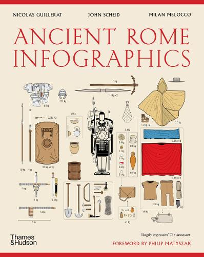
There’s no real alternative to a good browse around a bookshop, this book Ancient Rome Infographics by Nicolas Guillerat, John Scheid and Milan Melocco is the result of just such browsing. I’ve been interested in the history of Britain, and the important part the Romans played in it for a while so this was a welcome find. I’m interested in data visualisation, so it’s fair to say this is the sort of exercise I would undertake given data on the Roman Empire!

The authors emphasise several times that the underlying data for these infographics is sometimes uncertain and that there is pretty much no data prior to the fourth century BCE so this period is ignored. They provide an extensive bibliography although it is not referenced at an individual infographic level.

The book is divided into three parts:

  1. The Lands and People of the Empire
  2. Government, worship and social needs
  3. Rome’s military might

The infographics generally span a double page spread, and usually include explanatory text. I’m finding writing a review a bit challenging without reproducing the infographics, the publisher Thames & Hudson have some examples on their product page.

From the first section I liked the visualisation showing the physical extent of the Roman Empire and its growth in both population and area over time. I was surprised to learn that the Iberian peninsula contained a large chunk of the Roman population (5,000,000) compared to 7,000,000 in Italy. The population of Egypt was also significant (4,500,000) although it was absorbed rather later, in 27 BCE. The Roman Empire continued to expand until 150CE.

This section includes quite a lot of detailed information on Rome particularly in terms of the types of buildings in the city, and how the footprint of the city evolved over time. I assume that the Roman remains in Rome have been subject to a huge amount of study hence the large quantity of data. Rome grew to a population of 1.75 million in the 3rd century CE declining to 500,000 in the mid 5th century CE.

Also included are rather complex diagrams of the social and legal classes in Roman society. I must admit I found this less interesting. The authors mention several times that one of the strengths of the Roman Empire was that citizens from all the states across the Empire became fully fledged Roman citizens, as well as citizens of their local state. The social structure was very oriented around voting men, with the paterfamilias – the senior man in a household – essentially holding all of the rights the state bestowed which they distributed as they saw fit to their household. The paterfamilias might also have a patron-client relationship with others outside the household, I suspect this is one of many topics which warrants a whole book to elucidate.

The second section continues with the delineation of roles in society with the focus on the political and government. My favourite part here was the chronology of emperors which also introduced the term damnatio memoriae which is an attempt to expunge an emperor from the historical record. The term, although Latin, was coined in the 17th century. Some emperors had quite long reigns but at other times there were flurries of emperors, or at least those that proclaimed themselves so. This is where the infographic presentation falls down a bit – subtleties are lost because they cannot be presented cleanly. From towards the end of the third century CE there are Eastern and Western empires each with their own emperor and for a brief period there was the “Tetrarchy” – a system of two senior and two junior emperors.

Religion gets a few pages, Romans had a system of public and private “cults” – a city would follow a public cult with its ceremonies and rituals but individuals could also follow their own cult with a shrine and ritual in their home. Later the Christian faith was to spread through the Empire encompassing over half of the population by 350CE.

Also in this chapter is data on the production of grain, and the cost of living. For quite some period the residents of Rome had a “grain dole”, or annona which gave an allocation of grain to selected citizens of Rome (adult male citizens). The cost of living data is so interesting I’m tempted to do my own visualisations! For example 1 rabbit cost 32 as (a small Roman coin) but a pound of wild boar meet was only 8 as. 8 as would also buy you a prostitute but a bath was only 0.25 as. Slaves started at 800 as but went up to nearly 100,000 as for “1 very attractive slave”. A skilled worker could earn 12 as per day, a legionary (a junior rank) 10 as / day, a centurion 165 as / day and a senator 5480 as / day.

The final chapter covers war, I was a bit surprised to learn that the Roman army and navy were not that great but they made good use of local fighters and were good at simply being present. There are descriptions, and infographics of Roman marching orders, camp construction processes and the the evolving equipment of a Roman soldier. I sometimes wonder how accurately such prescriptions were followed, I assume there is at least one documentary source for these processes but how closely were they followed in the field?

I liked the visualisation showing movements of one Roman legionary through his career around Armenia and Eastern Europe. The Social Wars, Punic Wars, conquering Gaul and Spartacus have their own sections in this chapter. I’m assuming these are the most important of the Roman wars.

Overall I enjoyed this book, although I was sometimes frustrated by the complexity of the infographics. It works well as a taster for further investigation.

Book review: Roads in Roman Britain by Hugh Davies

My next review is of Roads in Roman Britain by Hugh Davies. Davies was a road engineer, and the study of Roman roads is a retirement project for him, which amused me since I am currently contemplating retirement. I don’t mean this pejoratively – I think in Roads he did a great job bringing together his expertise and the existing academic work in the area, as well as his own original research. He gained a PhD in 2001 from Reading University. In addition he has compiled a database of Roman road characteristics which is exactly my sort of thing.

The book starts with some basic definitions of what a road is and how it is structured. Davies focusses on the function of the road as a transport mechanism rather than as a boundary indicator, a navigation system or an expression of Roman power – uses I hadn’t really considered. As a structure a road has a route and a cross-section. I liked the quote from John London McAdam which basically said the function of the road cross-section was to stop the running surface becoming unusable as a result of water coming from above or below!

There is very limited primary documentary evidence for the Roman roads of Britain, there is the Antonine Iternary, tables of routes across the Roman empire which includes some routes in Britain and the Peutiger Tables, a sort of pseudo-map of roads across the Roman Empire of which Britain is only covered in a small fragment showing the far south east of the country.

This leaves us with archaeology, fortunately Roman roads in Britain have been excavated for many years. Less fortunately dating evidence is sparse in roads. Some roads identified as Roman may well date to medieval or even the 17th century when the turnpike roads were the first to match the quality of construction of Roman roads. It’s worth noting that none of the names used for Roman roads (Watling Street, Ermine Street, the Foss Way etc) are original – they are labels dating to the medieval period at earliest. It is not clear if Romans used any sort of naming for roads.

Archaeological practices have improved over the years, it is only really in the last quarter of the 20th century that it was appreciated that Roman roads are structures that were repaired and reconstructed over centuries.

I think the most interesting idea in this book Davis’s proposal for a reason for the straightness of Roman roads. He argues, unlike others, that the Roman’s must have made some sort of map before laying out roads and that the likelihood was that this was some large scale object possibly inscribed onto a floor. Under these circumstances straight road segments are the easiest to transmit to “the field”. It is easy to say “go to this point, build a straight road in this direction until you have gone this distance”, imagine trying to describe a more complex route accurately.

One of the recurring themes of the book is as to whether the Romans built roads to a strict pattern in terms of construction details and width. Justinian codified road classifications in the 6th century AD; an iter is pedestrian only, actus will allow a beast of burden, via will allow a cart however no numerical widths were defined. The Twelve Tables from fifth century BC says a straight section of road must be 8 pedes (Roman feet) wide on the straight an 16 on corners. However, on the ground road widths follow quite a broad distribution with a peak around 20 pedes (which is about six metres). This is wide enough for two-way cart traffic.

Based on the road surface (crushed stone/gravel) and the maximum gradients Davies suggests that Roman roads were designed for heavy carts moving at walking pace rather than fast passenger carriages. I was interested to learn the optimum gradients for carts are based on the rolling resistance of the surface balancing gravity (which becomes larger for steeper slopes). This is to avoid runaway carts since braking technology at the time was poor.

In the past historians have tended to the view that the Romans worked in a very regimented fashion. Davies comes down on the side of a more flexible approach determined by local factors. This is complicated in the archaeological record by repair and reconstruction activities, in some places there is evidence for 9 or 10 cycles of repair/reconstruction – sometimes this is as an addition on top of an older road but sometimes it is a widening of the route.

Davies observes that there is a difference in construction methods between the north and west of the country and the south and east with the north and west making greater use of stone. He attributes this to much more significant military use in the north and west, and better availability of suitable stone.

There is a chapter on Roman town plans which looked like it could be a whole separate book. Roman towns are typically built on a grid sometimes this grid is based around a Roman road alignment – suggesting road predates town and sometimes the road deviates to adapt to the town grid, suggesting town predates road.

Davies covers fairly briefly the development of the network over time, in terms of the military function of roads. The Royal Engineers estimated that the initial road from a Kent invasion landing point to London would have taken 1000 men about 15 weeks, a full version would take 3400 men about 3 years. The Roman road system was not fully developed until into the 2nd century AD – some 60 or so years after the invasion. London was not the transport centre of Britain at the beginning of the Roman occupation but became so over time.

This book is somewhat specialist, I enjoyed it because I’m interested in civil engineering and Roman history. It is short and readable, and I think provides a unique perspective.

Book review: Roman Britain – A New History by Guy de la Bédoyère

Following on from my previous review of Echolands by Duncan MacKay on Boudica’s revolt against the Roman occupiers of Britain, this review is of Roman Britain: A New History by Guy de la Bédoyère. Roman Britain has a much wider scope than Echolands covering the whole period of Roman influence in Britain from Caesar’s abortive invasions in 55 and 54BC through to the period after the Roman’s left Britain in 410AD. This is a larger format book with illustrations and photographs on virtually every page.

The book starts with three chapters on the timeline of Roman Britain covering the pre-invasion period, the extended conquest and the later period. Eight chapters follow on different themes: governing Britain, military installations, towns in Roman Britain, industry, commerce and production, the countryside and villas, people and places of roman Britain, religion in Roman Britain and the aftermath.

Britain was know to the Greeks as far back as the 4th century BC, and there was trade in tin from Britain from that time. By the middle of the 2nd century BC ornate burials were being found in Britain containing imported goods, and coinage was starting to be found. Hengistbury Head, where my father lived in his retirement, was an important trade port in this period. This tells us that Britain was not unknown to the outside world when Caesar made his invasion attempts in 55BC and 54BC. These were unsuccessful in the immediate sense but over the intervening years to the invasion proper in 43AD there was a gradual Romanisation of the upper echelons of British society, and increased trade.

Both Caesar’s abortive invasion, and Claudius’s successful invasion in 43AD were driven by politics in Rome, military success were a credit to an Emperor. British politics may well have played a part: Cunobelinus, king of a large chunk of Britain, died in 43AD and the resulting uncertainty over succession was a good opportunity to invade. Claudius’s invasion succeeded because the Roman army were a very efficient, well-equipped military force and their opposition was divided with some on the British side likely supporting the Romans.

The Romans spread to a line linking Lincoln and Exeter by 47AD, and by the end of the 1st century they had reached the limits of Wales and the far North of Scotland. Over the next 50 years there was some consolidation but by 150AD the Roman’s had reached the geographic limit of their occupation of Britain. It seems that the South-East of Britain became fairly well Romanised with villas and towns in the Roman style. North and West of the 47AD frontier life seemed to continue more in the manner of the Iron Age but for the addition of Roman garrisons and forts with related trade and industries.

Most of what we know of Roman life in Britain is based on the inscriptions left by the military, on tombstones and dedications of building works. There are limited number of wooden writing tablets, discovered at Vindolanda by Hadrian’s Wall and in London, which provide a fascinating insight into daily life, trade and interpersonal relationships. The early period of the occupation is discussed in Tacitus’s writings, as well as some other fragments.

We get a very small sample of daily life from from archaeology, only about 0.01% of all deaths are represented in burials and, assuming villas had 40 occupants each, homes for only about 0.01% are known.

Much of the rest of our understanding seems to come from recognising that Britain was being run like any other Roman province and extrapolating across archaeological and historical writings from all over the empire. Roman’s had firm ideas about which people could hold which positions (qualified by property), and Roman towns had a specific set of amenities according to their official type. Britain was seen as a troublesome province and had quite senior governors who typically only had a short tenure – some went on to become Emperor.

The Roman’s seemed to have respected the British as traders, seeing them as taking on Roman ways in this regard. Agriculture was important, and there is a lot of evidence of lead production – unlike iron, lead tends to survive quite well. Coinage was only minted in Britain from the late third century – it would not be used so heavily until the 17th.

There is limited evidence for the health and ethnicity of the Roman Britons, they seem to have increased dental issues. There was certainly the idea of branded medications, particularly for eye conditions. It isn’t clear whether there was a patent system. It is certain that Roman soldiers came from around the Empire but identifying them is hard since typically they Romanised their names.

Most of the writing we find the Roman period relates to religion (shrines, tombstones, altars). For a large part of the Roman period people worshipped hybrid Gods – amalgams of Roman Gods with local pagan deities or even from elsewhere in the Roman empire. Later the Christian church became established – we have written evidence of a church hierarchy from 314AD.

From the beginning of the third century AD the Roman empire was beginning to split up. Rome finally withdrew support for the military occupation of Britain in 410AD. This had an immediate economic impact because there was no longer new coinage coming into the country, or military salaries to spend. Physically Roman buildings decayed over a period of 150 years or so with the now non-Roman occupants no longer having the will or skill to repair them. We can mark the complete end of practical Roman influence with the invasion of the Anglo-Saxons in 577AD although we see the marks of the Roman occupation even now in our landscape and language.

Roman Britain finishes with a chronology and a guide to visiting Roman sites in Britain, I feel in this section insufficient attention is paid to my home town of Chester!

This is a beautiful book, and rather readable.

Book review: Echolands by Duncan MacKay

One book leads to another, after reading about prehistoric Britain I was interested in what came next – the Romans. Someone on social media suggested Echolands by Duncan MacKay subtitled A Journey in Search of Boudica. This is an apt description, the book is part travelogue, part history book. MacKay describes his journey following the path of Boudica to Colchester, London, Verulamium and to a final Great Battle with Paulinus, the Roman governor of Britain at the time. He travels variously by car, foot and bicycle. Initially I was sceptical of this style but it is rather compelling – the journey acts as a kind of mnemonic map for the historical facts conveyed.

Britain’s written history starts with Caesar’s expeditions in 54BC and 55BC. It was written not by the British but the Romans. Caesar did not conqueror any territory in Britain but extracted tribute from one king, and set up another as a client. This seems to have started a slow Romanisation of Britain with the local elites seeing the luxuries available in the Empire, and their sons going to Rome for a civilised upbringing (it isn’t quite clear if this export was voluntary). Britain already made some use of coinage which I find intriguing in a supposedly pre-literate society. There is scant archaeology from this period but a number of hordes of valuable items have been recovered.

The action then moves onto the Roman invasion in 43AD, over a 40 year period something like 250,000 Britons would lose their lives to the Romans, and it is likely 250,000 more were taken into slavery – this is from a population of around 2 million. The initial invasion force was around 40,000. The conquest was a slow process with some outright military victories and alliances or arrangements with the existing kingdoms as well as a lengthy and brutal campaign in Wales. The subjugation of Wales was to take until 51AD, veterans of this campaign retired to Camulodunum (Colchester) where they formed a colony. Relevant from this period is King Prasutagus of the Iceni tribe, whose wife was Boudica.

On his death Prasutagus in 59AD attempted to make his wife, Boudica, heir to his kingdom alongside Rome. Rome did not take kindly to this, Boudica was whipped and her two daughters raped. Subsequent events are recorded by Tacitus in The Annals (English version here, original latin here). There are also some references in Cassius Dio’s Roman History (English version here). These are relatively brief accounts and much of the understanding of events turns on a couple of sentences. Apparently Romans referred to us as Britunculi – “little Britons”!

In 60AD Boudica and her allies attacked the Camulodunum colony, killing effectively all of its inhabitants and burning it to the ground. The destruction can be seen in the archaeological record, and in fact burning has preserved more of the wattle and daub and other wooden structures than would normally be found. The final redoubt of the Roman colonists was the extravagant Temple of Claudius which was besieged for two days according to Tacitus.

On hearing news of the massacre the 9th Legion from set out towards Camulodunum via Cambridge. MacKay thinks they started from Longthorpe (outside Peterborough) whilst others suggested they started from their main garrison in Lincoln. This is where MacKay first takes to the road in earnest, travelling along the A14 to Cambridge, at the time this was the Via Devana (The Chester Road). MacKay is keen on his caligae (Roman hobnailed sandals) with which he walks some of the route. We lived in Cambridge for nearly 10 years and I know the A14 well, now we live in Chester. So this leg of the journey strikes a cord. The 9th legion were massacred somewhere outside Camulodunum, MacKay suggests the Colne Valley as a likely location for the ambush. This seems to be largely on the basis of where he supposed they were coming from and the local geography. There is no archaeological evidence for the battle.

In the meantime the Roman governor of Britain at the time, Gaius Suetonius Paulinus, is invading Anglesey where the last Welsh resistance is holding out. Tacitus notes of the women in the opposing forces ranks:

In the style of Furies, in robes of deathly black and with dishevelled hair, they brandished their torches; while a circle of Druids, lifting their hands to heaven and showering imprecations, struck the troops with such an awe at the extraordinary spectacle that, as though their limbs were paralysed, they exposed their bodies to wounds without an attempt at movement. 

Despite this they are beaten easily by Paulinus’s legionnaires. MacKay travels to the vicinity of RAF Valley on Anglesey to start his retrace of Paulinus’s rapid trip south to face Boudica. We spent our summer holiday in Rhosneigr – a couple of miles away! The site is interesting because a number of artefacts were discovered in the lake there. One of them, a slave chain, was actually used by workers in the 1940s conducting a peat excavation operation and survived the experience remarkably well!

It is thought that Paulinus prepared his invasion boats (likely flat bottomed barges), in Chester and on his trip back to London – on news of Boudica’s rebellion – at least part of his force probably sailed back to Chester. Paulinus then takes his force south to London likely heading down towards Wroxeter (near Shrewsbury) along the now vanished start of the Watling Street Roman road before following it onwards to London along the still existing line of Watling Street. MacKay follows this route by car stopping on the outskirts of London to travel by rail and foot to the area of Monument, the centre of Roman London.

In 60AD London was a thriving trading centre but does not appear to have been an important town to the Romans from an administrative point of view, furthermore it did not have significant defences at the time so on his arrival Paulinus decided to abandon London to Boudica’s forces who were heading down from Colchester. He departed with those able and willing to follow, some may have taken refuge from Boudica on boats in the Thames. In any case London was comprehensively burnt by Boudica’s forces. Paulinus then headed up toward Veralumium (near modern day St Albans) which Boudica also destroyed.

That was the limit of Boudica’s rebellion, MacKay spends some time visiting potential locations for the final Great Battle of which Tacitus just says “…a position approached by a narrow defile and secured in the rear by a wood…“. This location has been the subject of much discussion with locations up into Warwickshire finding favour. MacKay appears to have decided on Windridge Farm close to Veralumium on the basis of the geography of the area, the proximity to a know location for Boudica and the discovery of clusters of Roman slingshot . Wherever it was Tacitus claims 80,000 of Boudica’s forces were killed in a single engagement, for comparison the first day of the Battle of the Somme saw 20,0000 British troops died. This ended Boudica’s rebellion and Tacitus says she died by her own hand afterwards.

The Roman’s lost a similar number of soldiers and civilians during the rebellion. What surprised me is despite these huge battles in the Colne Valley, on Anglesey and close to St Albans there is minimal archaeological evidence from these sites. Part of the problem is no doubt the uncertainty of their location, but also 80,000 dead on the ground surface would likely disappear over a period of a few years. Armour and weapons were valuable and would have been cleared from the battle field. MacKay references reports from other Roman battles, the Indian Rebellion and a battle between the British and Zulus, as to how such locations appeared after a few months or years.

The Romans were brutal occupiers, as evidenced by their own historians, and the carved columns they raised in honour of victorious generals. Boudica’s forces were brutal too. It would have taken the Romans a number of years to recover from the rebellion, furthermore the local population struggled through famine in the aftermath of the rebellion (Tacitus puts the blame for this squarely on the British).

I enjoyed this book, I thought the combination of travelogue and history worked really well and by chance I was familiar with a number of the locations MacKay visits.

Book review: Roman Chester by David J.P. Mason

roman_chesterI recently realised that I live in a city with rather remarkable Roman roots. Having read Mary Beard’s book, SPQR, about the Roman’s in Rome, I turn now to Roman Chester: Fortress at the Edge of the World by David J.P. Mason.

The book starts with a chapter on the origins of the study of the Roman origins of Chester, and some background on Roman activities in Britain. The study of the Roman history of Chester begin back in the 18th century, with the hypocaust under the old Feathers Inn on Bridge Street a feature promoted by its owner. The Spud-u-like on the site now similarly boasts of its Roman remains. The original Roman east gate was still standing in the 18th century, and there exist several drawings of it from that period. The Victorians were keen excavators of the Roman archaeology, and formed the Chester Archaeological Society in 1849, and built the Grosvenor Museum in 1883.

A recurring theme of the book is the rather wilful destruction of substantial remains in the 1960s to build a couple of shopping centres. The Roman remains on the current Forum Shopping Centre site were destroyed after the rather fine Old Market Hall had been knocked down.

The core Roman activity in Chester was the fortress, established in 75AD under the reign of Vespasian. The fort is somewhat larger than other similar forts in England and the author suggests this was because it was, at one time, intended as the provincial governors base. Vespasian died shortly after the building of the Chester fortress started and the work paused. At the time of its Roman occupation Chester had a very fine harbour, the local sandstone was suitable for building, a brickworks was setup at Holt, further up the River Dee, and there was metal mining in North Wales and there was salt sourced from Northwich – all very important resource at the time.

Standing on the river Dee meant Chester could serve as a base for the further conquest of Britain and Ireland – although these plans did not come to fruition.  The evidence for this is some unusual buildings in the centre of the old fortress, and the rather more impressive nature of the original walls than the average Roman fort, and the discovery of rather classier than usual lead piping.

The book continues with a detailed examination of the various parts of the Roman fortress and the buildings it contained: the public baths, granaries and barracks. This is followed by a discussion of the surrounding canabae legionis, including the amphitheatre, the supporting Roman settlement and the more detached vicus. This includes the settlement at Heronbridge which was excavated relatively recently.

The third part of the book travels through time, looking at the periods c90-c120 in which the fortress was rebuilt, c120-c210 when the legion stationed at Chester was sent elsewhere to fight leaving the fortress to decline significantly. c210-c260 when the original impressive buildings at the heart of the fortress, not initially completed, were finally built. c260-c350 when the fortress fell and rose again. To finish in the period c350-c650 when Britain became detached from Rome, and fell into decline. The Roman fortress was robbed to provide building stone for the medieval walls and other structures including the cathedral.

Roman remains are visible throughout modern Chester. The north and east parts of the modern city walls follow the line of the walls of the Roman fortress. Some pillars are on display in front of the library, the hypocaust found under the Grosvenor shopping centre can now be found in the Roman Gardens, the amphitheatre is half exposed, parts of the walls particularly near Northgate and parallel to Frodsham street are contain Roman elements, the mysterious “quay wall” can be found down by the racecourse.

The book finishes with some comments on the general character of the investigations of Roman remains in Chester, and suggestions for further investigations and how to better exploit Chester’s Roman history. On the whole Chester has done moderately well in its treatment of the past, study started relatively early but much material has not been published. These days archaeology is mandated for new developments in the city but these tend to be rapid, keyhole operations with little coherent design.

Roman Chester is a rather a dry read, it is written much I would expect an article in a specialist archaeology journal to be written. The book could have done with a full double page map of modern, central Chester with the archaeological sites marked on it. As it was I was flicking between text descriptions and Google Maps to work out where everything was. Perhaps a project for the Christmas holiday!

If you are a resident of Chester then the book is absolutely fascinating.

Update

I’ve started making a map of Roman Chester on Google Maps.